Introduction
Latitude and longitude are two of the most important concepts in geography, enabling us to accurately describe the location of any place on Earth. This article will explore the basics of latitude and longitude, as well as how they can be used to read a map, understand weather patterns, calculate distances, and navigate. Additionally, we will discuss the history of this concept and its importance in modern times.

Exploring the Basics of Latitude and Longitude
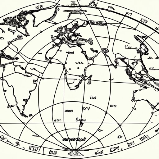
Latitude and longitude are imaginary lines that are used to divide the surface of the Earth into sections. The horizontal line is known as latitude, while the vertical line is known as longitude. Together, these lines form a grid-like pattern across the globe, which allows us to pinpoint exact locations.
Latitude is measured in degrees, minutes, and seconds. Degrees are the largest unit of measurement, with each degree divided into 60 minutes and each minute divided into 60 seconds. Similarly, longitude is also measured in degrees, minutes, and seconds. The starting point of both latitude and longitude is the Prime Meridian, which is located at 0° longitude. The Equator is the starting point for latitude and is located at 0° latitude.
How to Read a Map Using Latitude and Longitude Coordinates
Once you understand the basics of latitude and longitude, it becomes much easier to read a map. To find a specific location, look for the coordinates along the edges of the map. These coordinates will be labeled with the corresponding latitude and longitude. For example, a coordinate of “45°N, 90°W” would indicate that the location is 45° north of the equator and 90° west of the Prime Meridian.
Once you have the coordinates, you can plot them on the map. To do this, simply draw a line from the given latitude to the given longitude. The point where the two lines intersect is the location you are looking for.

The Impact of Latitude and Longitude on Weather Patterns
Latitude and longitude play a major role in determining the climate of a certain area. This is because the closer a location is to the equator, the more direct sunlight it receives, resulting in higher temperatures. Conversely, locations farther away from the equator receive less direct sunlight, resulting in cooler temperatures. However, it is important to note that longitude does not have the same effect on temperature as latitude. This is because the Earth rotates around its axis, meaning the sun is always in the same position relative to the longitude lines.
In addition to temperature, latitude and longitude also affect precipitation. Generally, areas near the equator receive more rainfall due to the warm air rising and forming clouds. On the other hand, areas farther away from the equator tend to be drier due to the colder air not being able to hold as much moisture.
Exploring the Relationship Between Latitude and Longitude
Latitude and longitude lines come in different forms. For example, there are parallels of latitude, which are circles of equal distance from the equator. There are also meridians of longitude, which are half circles extending from the North Pole to the South Pole. Additionally, there are time zones, which are based on 15° intervals of longitude.
Time zones are essential for keeping track of the time, as they determine when the sun rises and sets in different parts of the world. For example, if you are located at 45°W longitude, then the sun will rise and set one hour earlier than if you were located at 30°W longitude.
Using Latitude and Longitude to Calculate Distance
Latitude and longitude can also be used to calculate the distance between two points. To do this, you must first convert the coordinates into Cartesian coordinates, which are points on a three-dimensional grid. Then, you can use the Pythagorean theorem to calculate the distance between the two points. This calculation is known as the great circle distance.

Understanding the Role of Latitude and Longitude in Navigation
Latitude and longitude play an important role in navigation. By using a combination of coordinates and a compass, sailors have been able to navigate the seas for centuries. Today, modern navigation tools such as GPS and satellite imagery make use of these concepts to help people navigate by land, sea, and air.

An Overview of Latitude and Longitude: A Historical Perspective
Latitude and longitude have been used since ancient times. In fact, the earliest known maps date back to the Babylonian Empire, which used a system of latitude and longitude to accurately depict the world. Over the centuries, the concept of latitude and longitude has evolved, becoming more accurate and sophisticated with the development of modern maps.
Conclusion
Latitude and longitude are two of the most important concepts in geography. They enable us to accurately describe the location of any place on Earth and can be used to read a map, understand weather patterns, calculate distances, and navigate. Additionally, this concept has a long history, dating back to ancient times. Understanding the basics of latitude and longitude is essential for anyone who wishes to explore the world.
(Note: Is this article not meeting your expectations? Do you have knowledge or insights to share? Unlock new opportunities and expand your reach by joining our authors team. Click Registration to join us and share your expertise with our readers.)